Deformation in the northern edge of the S„o Francisco Craton adjacent to the SE part of the Sergipano Belt (NE Brazil):
mountain building by underthrusting.
Luiz J.H. Dīel-Rey Silva
UnB – IG
Campus UniversitŠrio Darcy Ribeiro, Asa Norte
BrasŪlia – DF
e-mail: ldel-rey@unb.br
INTRODUCTION: FEW WORDS ABOUT THE SERGIPANO BELT
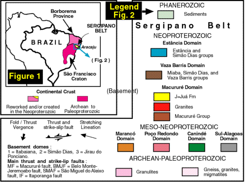
The Sergipano Belt is a Meso-Neoproterozoic, WNW-ESE trending wedge of poly deformed-metamorphosed rocks situated between the Borborema Province (BP) and the S„o Francisco Craton (SFC), in NE Brazil (Fig. 1). It is part of a mega orogen that stretches for over 2000 km along the northern margin of the S„o Francisco – Congo Craton of western Gondwana, and comprises seven lithotectonic domains (Fig. 2). These are interpreted as the record of the continental collision of an Andean-type and an Atlantic-type continental margins with a main suture along the Belo Monte-Jeremoabo fault (interpretation and synthesis of data in D’el-Rey Silva 1999). The belt is divided in two parts by the Tucano / Sergipe-Alagoas Phanerozoic basins.
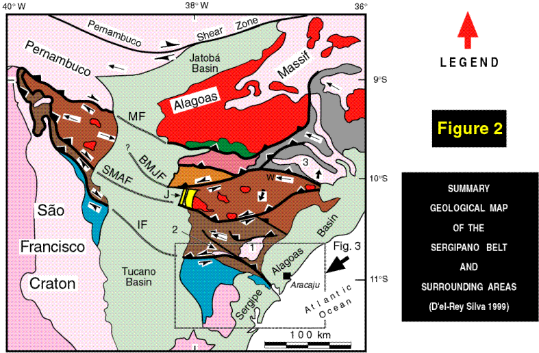
The Andean-type margin (to the north of the fault) developed along the southern margin of the Pernambuco-Alagoas Massif (Pe-Al), part of the BP, and consisting of Archean-Paleo and Neoproterozoic gneiss, migmatites and granitoids). It comprises the Sul-Alagoas Domain, formed by a set of rocks akin to an accretionary prism, as well as metasediment remnant of a Meso-Neoproterozoic passive continental margin (around the Jirau do Ponciano gneiss dome), plus the Canindť and Maranců domains (island arc-type plutonic and volcano-sedimentary rocks), and the PoÁo Redondo Domain - migmatites of a probable continental block. U-Pb age data and geochemistry data in Silva Filho (1998) indicate that the margin evolved since ˜ 1000 Ma, and the oceanic terranes plus the continental block amalgamated to the southern margin of Pe-Al, afterwards, with at least one age record of these events around 715 Ma.
The Atlantic-type margin developed in the ˜1100-650 Ma interval along the edge of the SFC and comprises a craton-belt continuous continental-miogeoclinal-eugeoclinal wedge of sedimentary (volcanic) rocks that are part of the Macururť, Vaza Barris and Est‚ncia domains. According to Santos et al. (1988) the Macururť Domain comprises amphibolite to low-greenschist metasiliciclasts (basal quartzites, schists, slates), minor metacarbonates, and metavolcanics of the Macururť Group, plus slices of mylonitic crystalline basement, granite intrusions and a molasse basin (the depocenter of the JuŠ Formation). According to D’el-Rey Silva (1992), D’el-Rey Silva & McClay (1995) the Vaza Barris Domain comprises low-greenschist facies metasediment and metavolcanics divided into the Miaba, Sim„o Dias and Vaza Barris groups. These rocks surround basement amphibolite-grade gneiss domes of Archean-Paleoproterozoic age, two of them respectively termed Itabaiana and Sim„o Dias domes (Fig. 2). Within the SFC, the Est‚ncia Domain comprises siliciclastic and carbonate sediments divided into the Est‚ncia and Sim„o Dias groups, and their Archean-Paleoproterozoic crystalline basement.
Collision of the two margins was oblique sinistral and took place around 650-600 Ma, in the Brasiliano / Pan-African orogenic cycle after consumption of the oceanic crust that subducted to the north (D’el-Rey Silva 1992) so that the SFC and its margin underthrust the Andean-type margin. As a consequence, apart from the JuŠ molasse basin and the Est‚ncia Domain, most of the Sergipano Belt displays evidence of polyphase folding and faulting, with a conventional fold-thrust vergence to SSW (Fig. 2). However, deformation in the Sul-Alagoas Domain is probably polycyclic (Amorim et al. 1993, Amorim 1995) and displays a fold-thrust vergence generally to northerly directions. The scenery points out to an older deformation during the tectonic evolution of the Andean-type margin overprinted by a younger event during the Brasiliano collision. Most of the thrust – strike slip faults in the Vaza Barris Domain have been interpreted as positively inverted normal faults (Fig. 2, D’el-Rey Silva 1992).
A I M S
This work presents a summary of the structural data recently collected (October 1998) in most of the Est‚ncia Domain to the south of parallel 100 50’S and to the east of meridian 38000’W (Fig. 3). The data indicate plenty of evidence for a surprising scenery of deformation that differs from the one observed in the Vaza Barris Domain, both in style and intensity. Nevertheless, the abundant structures in the so-called craton area fit well in the underthrust of the SFC to NNE, during which the SSW-verging folds and faults developed in the belt.
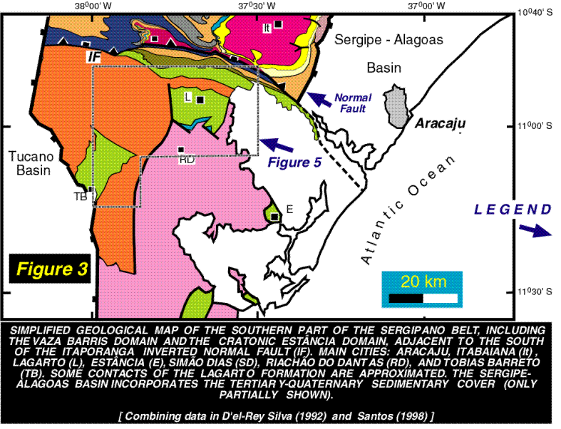
THE SOUTHERNMOST PART OF THE SERGIPANO BELT
The Itaporanga fault (Fig. 3) separates the Est‚ncia Domain from the rest of the belt. However, sedimentation (˜1100 to ˜ 650 Ma), as well as both the contractional deformation and metamorphism (˜ 650 – 600 Ma) were continuous across the fault boundary and vanish gradually towards the SFC. Thus, the cratonic sediments are generally flat-lying, with low angle of dip generally to northerly directions (D’el-Rey Silva 1992, 1995a). A detailed stratigraphy and structural analysis carried out to the north of parallel 100 50’S, in an area that includes the northern part of the Est‚ncia Domain and the Vaza Barris Domain (D’el-Rey Silva 1992, D’el-Rey Silva & McClay 1995) led to the definition of the lithostragraphy of the southernmost part of the belt (Fig. 4). Previous detailed descriptions of the rocky units in the Macururť, Vaza Barris and Est‚ncia domains (summary of authors in the references above) were also taken into account.
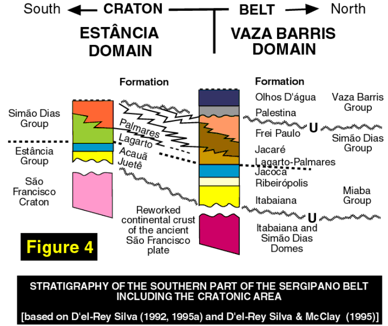
Lithostratigraphy The Sim„o Dias Group (SDG) is a blanket of coarse-grained siliciclastics that spread from south to north, resting conformably on the Est‚ncia Group, in the craton, and on the Miaba Group, in the basin. The SDG also rests unconformably on the crystalline basement in the craton area, and around the gneiss domes, in the basin, it is unconformably overlain by the Vaza Barris Group (Fig. 4).
The Est‚ncia Group unconformably overlies the basement and comprises the JuetÍ (quartzite, mudstone, argillite, diamictite and consists of arkosic sandstone, with conglomerate lenses of basement-derived clasts) and the Acau„ (carbonate) formations. These rocks are only found in a very particular area to the south of the Lagarto City (Fig. 3) between the Lagarto beds and the crystalline basement. The SDG starts, in the craton, with the Lagarto Formation that consists of thin mudstones / argillites and interbedded siltstones, passing upward into well-laminated layers of sandstones with intercalated layers of mudstones, argillites and siltstones. The Lagarto beds clearly interfinger with the Palmares Formation that consists of generally 1 m-thick layers of sandstones, arkoses and lythic wackes, with intercalated layers of mudstone commonly no thicker than 5 cm. To the north, still in the Est‚ncia Domain, these two formations pass gradually into the Jacarť metasiltites and the Frei Paulo phyllites (Fig. 3). In the Vaza Barris Domain, the Miaba Group comprises the Itabaiana basal quartzites (conglomerates) and meta-argillites, the Ribeirůpolis (pebbly) phyllites, metadiamictites, and metavolcanics, and the Jacoca metacarbonates. The SDG comprises the Lagarto-Palmares sandstones (undifferentiated for reasons of scale) plus the Jacarť and Frei Paulo formations, as seen around the domes. The Vaza Barris Group comprises the Palestina metadiamictites and the Olhos D'Šgua metacarbonates
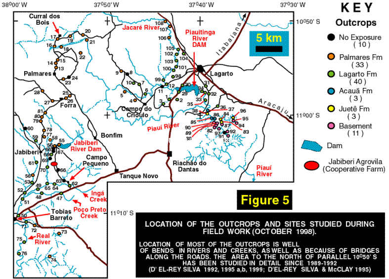
The study area The area is relatively populated, and the access to the outcrops (the majority of these are along rivers and creeks) is largely facilitated by a good net of roads (Fig. 5). About 108 localities were visited in the field (October 1998), and in 98 of them were encountered outcrops of general good quality, and the quantity of outcrops guarantees a good coverage of the Est‚ncia Domain. The Neoproterozoic sediments that occur around the Est‚ncia City (Fig. 3) shows no evidence of deformation in 8 studied outcrops (out of Fig. 5). Since 1995 the author has demonstrated the interdigitation of the Lagarto and Palmares formations in the center of the Est‚ncia Domain, too. The data fully agree with detailed sedimentology and stratigraphy studies carried out (Saes 1984) in an area ˜ 25 km SE of the Tobias Barreto City (SW corner of Fig. 3). A craton source for the Palmares Fm fit in detailed provenance data and conclusions in Saes & Villas Boas (1989). Although not included in here, Sm-Nd data obtained in the last day of preparation of this text, from 8 samples collected during field work in 1998, have revealled a Paleoproterozoic source area for the Lagarto and Palmares beds, confirming entirely the cratonic source area.
DEFORMATION IN THE EST¬NCIA DOMAIN
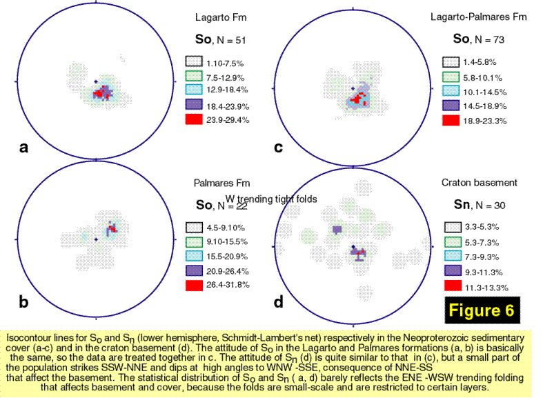
The Neoproterozoic cover Since D’el-Rey Silva (1992, 1995a) it has been demonstrated that the Olhos D'Šgua, Frei Paulo, Jacarť formations that occur just to the south of the Itaporanga fault (Fig. 3) are generally well-foliated and, in places close to the fault, they are highly folded. The folds are generally tight, steeply inclined to upright, verge to SSW, and their scale is generally = 1m. No evidence of two foliation and two fold phases have been found, however. The Lagarto-Palmares Formation, in the same area, does not appear to be as folded as the other formations and not so foliated as well. The more recent work has demonstrated that the foliation (S1) that affects these formations also affects the Lagarto Formation, since around the homonymous town up to the Tobias Barreto City, far in the southern part of the area (Fig. 5). The difference is that S1 does not affect the entire vertical succession of Lagarto layers, and deformation is clearly partitioned in consequence of the relative competence of the beds. Field work has also shown that sedimentary cover and basement display the same basic orientation of primary planar structures (Fig. 6).
The contrast of grain size and thickness (= contrast of competence) of layers in both the Lagarto and Palmares formations (herein LaFor and PalFor) exerted a key control on the style of deformation in the cratonic sediments. Both formations comprise well-layered rocks. The thickness of LaFor sandstone and siltstone layers ranges from 1 to 10cm, and only locally the sandy layers reach 1m, whereas the fine-grained layers [(meta) argillites and pelites] varies from few mm to few cm, only locally attaining 10cm. Other critical factor is the greater thickness of the PalFor sandstones (normally around 1m) and their high degree of cementation.
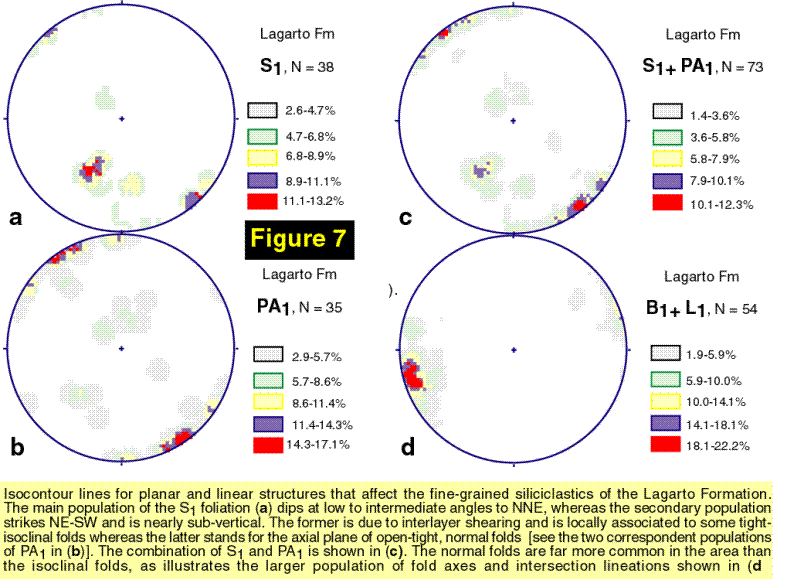
Whereas the Lagarto beds of fine-grained siliciclastics (herein FG) systematically exhibit the S1 foliation, the coarse-grained beds (herein CG) are boudinaged or are affected by three or four sets of joints. The foliation is a slaty cleavage or a pressure solution type in outcrops closer to the Lagarto City, whereas closely-spaced planes of partition are more common farther to the south. S1 is sub-parallel to, or display low-intermediate angle of obliquity with the borders of the layers. In some localities S1 is axial plane to tight-isoclinal folds scaled to few cm and verging either to southerly or northerly directions. Other relevant aspects are as follows. 1 - A single LaFor FG layer may exhibit evidence of ductile thinning and brittle-ductile extension in areas adjacent to other (few centimeters away) displaying compression structures (folds). 2 - S1 is locally cross-cut at low angle by another foliation of the same type (S1a). 3 – Thin layers of siltitone and sandstone (LaFor) may be found disrupted and the fragments rotated within an argillite-pelite matrix – a typical breccia due to differential flow within a thinly bedded FG layer. 4 – In several localities the LaFor FG beds are affected by open-tight, dm-scale, generally upright folds with sub-horizontal axes striking ENE-WSW. These folds are far more common that the other ones, and affect layers already deformed by S1 or not. They also develop a sub-vertical axial plane foliation of the type of spaced cleavage or a crenulation cleavage.
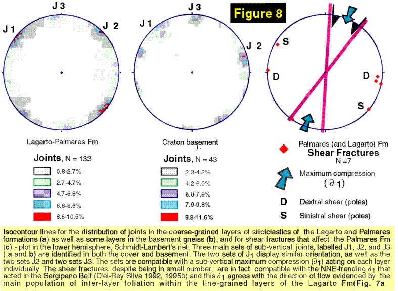
The stereogram for S1 and the axial plane (PA1) and axial planar foliation of the upright folds clearly allow demonstrate that S1 (sub-parallel or at low-angles to the layers) keeps the same orientation of S1 that is pervasive in the area to the north of the study area and wihin the Sergipano belt (see data and discussion in Fig. 7). The PalFor CG beds are systematically affected by the same sets of joints as the LaFor CG beds (Fig. 8 a-b) but only very locally the PalFor FG layers exhibit a foliation such as S1. Instead, the PalFor FG layers are commonly very well laminated. The different sets of joints in LaFor and PalFor CG beds are extremely well-defined in the outcrops, being the fractures very sharp and straight, so that, at each outcrop, few measurements are enough to characterize each set (Fig. 8).
The structural data are only explained by internal flow in the FG layers, whereas jointing of the CG layers is explained by a sub-vertical maximum compression due to the internal flow in the FG layers. The same NNE-trending compressive field of the Sergipano Belt explains deformation of the craton area (see discussion in Figs. 7 and 8) but the intra-layer flow must have resulted from the slide of all layers to NNE, not to the south and not due to a push from behind in the Vaza Barris Domain.
The crystalline basement The basement was studied in 11 outcrops, 7 of them of large scale (dimensions of 10 to 100 meters) and occurring closely spaced to each other, along the Piauitinga River (Fig. 5). Two sets of outcrops [(90, 82, 97) and (88, 89, 92, 93)] alternatively display folding or intense jointing. Their scale and N-S succession along the river (90, 89-88, 82-97, 92-93) allow understand that the basement and cover displays at least the same kind of vertical partition of deformation. The folds are of two generations: one generation comprises N-S trending, m- to dam-scale, tight and upright folds, with a spaced-cleavage-type axial plane foliation; and the other comprises E-W, NE-SW, NW-SE trending folds scaled from 1 to 10m, open-tight, upright, associated to a spaced cleavage axial plane foliation. Fold axes of both generations are sub-horizontal and strike sub-parallel to axial planes. In outcrop 82 both generations occur together, being the latter folds younger than the former ones. The joints are also extremely well-defined, and have the same orientation as in the LaFor and PalFor beds (Fig. 8 a-b).
The intercalation of outcrops displaying folds and joints strongly suggests similar deformation process, and vertical partition of strain, in the cover and basement. In addition, despite the older folds in the basement may be Paleoproterozoic, all folds observed in the gneiss also fit in the NNE-driven flow that affected the cover. Late transcurrencies also affect the area, and at least those in the PalFor (and also LaFor) beds fit in the general NNE-trending compression (Fig. 8c). The basement displays transcurrencies of similar orientation, but also two other populations. Interpretation of the latter requires additional field work.
CONCLUSIONS
Structures in the cratonic area adjacent to the Sergipano Belt are abundant in both the Neoproterozoic cover and its crystalline basement, and tell a story of vertical and horizontal partition of strain compatible with intra-layer flow driven to the north or NNE. The flow took place in less competent, FG layers, and induced brittle deformation in the more competent, CG layers. The likely scenery is the slip of the Neoproterozoic cover down to the north (underthrust) together with the ancient margin of the S„o Francisco Plate.
Remarks More than one hundred photographs taken in the field would illustrate in detail the structures observed in several key outcrops of the study area. However, the lack of room has led to: 1- Only those in Figures 9-12 are shown; and 2 - Several details were omitted in the text, as well as many other key references. A full paper is being elaborated on the matter of this poster presentation. The key references are in D’el-Rey Silva’s PhD thesis and papers.
Acknowledgments Very much I thank CNPq, and FINATEC – UnB, BrasŪlia, Brazil - for the financial support that has allowed me study the Sergipano Belt and the S„o Francisco Craton. Prof. Dr. B.B. Brito Neves (USP-Brazil) is thanked for introduce me (1995) to the S1 foliation in an outcrop close to the Bonfim village (Fig. 5), within the craton and far to the south of my PhD study area (1989-1992).
REFERENCES
Amorim, J.L., Torres, H.H.F. and Silva Filho, M.A. da 1993. O Complexo de embasamento da Faixa Sergipana na regi„o de Jirau do Ponciano (Al): Estratigrafia, evoluÁ„o tectonometamůrfica e potencialidade metalogenťtica. In SBG Simpůsio de Geologia do Nordeste 15, Natal, Boletim de Resumos , 240-242.
Amorim, J.L. 1995. Programa Levantamentos Geolůgicos BŠsicos do Brasil. Arapiraca, Folha SC.24-X-D-V. MME-SME-CPRM, 100p.
D'el-Rey Silva, L.J.H. 1992. Tectonic evolution of the southern part of the Sergipano Fold Belt, northeastern Brazil. Unpublished PhD Thesis, Royal Holloway University of London, England, 257p.
D'el-Rey Silva, L.J.H. 1995a. Tectonic evolution of the Sergipano Belt, northeastern Brazil. Revista Brasileira de GeociÍncias 25, 315-332.
D'el-Rey Silva, L.J.H. 1995b. The evolution of basement gneiss domes of the Sergipano fold belt (NE Brazil) and its importance for the analysis of Proterozoic basins. Journal of South American Earth Sciences 8, 325-340.
D’el-Rey Silva, L.J.H. 1999 - Basin infilling in the southern-central part of the Sergipano Belt, NE Brazil, and implications for the tectonic evolution of the Pan-African/Brasiliano cratons and Neoproterozoic sedimentary cover. Journal of South American Earth Sciences 12(5), 453-470.
D'el-Rey Silva, L.J.H. and McClay, K.R. 1995. The Southern Part of the Sergipano Belt, NE Brazil: Stratigraphy and Tectonic Implications. Revista Brasileira de GeociÍncias 25, 185-202.
Saes, G.S. 1984. Estratigrafia e sedimentologia do Grupo Est‚ncia na regi„o Nordeste do Estado da Bahia. Unpublished MSc Thesis, Universidade Federal da Bahia - Brazil, 107p.
Saes, G.S. & Villas Boas, G. 1989. Depůsitos de leques costeiros (Fan Deltas) e de plataforma marinha rasa do Grupo Est‚ncia, Proterozůico Superior (Bahia e Sergipe). Revista Brasileira de GeociÍncias 19(3), 343-349.
Santos, R.A. 1997. Programa Levantamentos Geolůgicos BŠsicos do Brasil (PLGB), Geologia e recursos Minerais do Estado de Sergipe. CPRM, BrasŪlia, 156p.
Santos, R.A., Menezes Filho, N.R., and Souza, J.D. de 1988. Programa Levantamentos Geolůgicos BŠsicos; carta geolůgica, carta metalogenťtica e previsional, 1:100.000, Projeto Carira. DNPM/CPRM, Brasil, 4v.
Silva Filho, M.A. da 1998. Arco Vulc‚nico Canindť-Maranců e a Faixa Sul-Alagoana: SequÍncias OrogÍnicas Mesoproterozůicas. In SBG Congresso Brasileiro de Geologia 40, Belo Horizonte, Anais, p.16.