UNIVERSIDADE DE BRASÍLIA / INSTITUTO DE GEOCIÊNCIAS
![]()
![]()
UNIVERSIDADE DE BRASÍLIA
/
INSTITUTO DE GEOCIÊNCIAS
TESE DE DOUTORADO No 094

TATI DE ALMEIDA
CONTRIBUIÇÃO DAS IMAGENS R99SAR E DE DADOS GEOFÍSICOS PARA O MAPEAMENTO GEOLÓGICO DO RIFTE ARAÍ, NORDESTE DE GOIÁS
DATA DA DEFESA: 03/07/2009
ÁREA DE CONCENTRAÇÃO: Processamento de dados em geologia e análise ambiental
ORIENTADOR: Prof. Paulo Roberto Meneses (UnB)
EXAMINADORES: Prof. Nilson Francisquini Botelho (UnB); Prof. Edson Eyji Sano (UnB); Prof.
Pedro Walfir Martins e Souza Filho (UFPA); Profa. Silvia Beatriz Alves Rolim (UFRGS)
Palavras-chave: R99SAR; multipolarização; mapeamento geológico
Limites de Retângulo Envolvente:
Folha ao Milionésiomo: SD23
Estado: GO
RESUMO
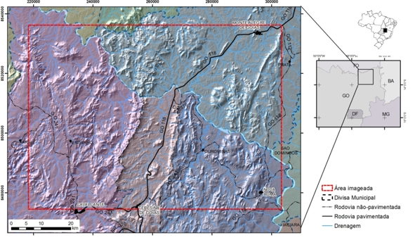
Nos últimos seis anos a comunidade científica brasileira vem obtendo acesso a dados SAR com múltiplas polarizações e alta resolução espacial através das plataformas aéreas R99 pertencentes ao Sistema de Proteção a Amazônia (SIPAM). No entanto ainda existe uma carência em relação ao corpo técnico no país, limitando a disseminação nas diferentes áreas da ciência no uso destas imagens, incluindo a geologia. Esta pesquisa demonstra que a possibilidade de configuração da geometria de aquisição de dados, do modo de operação, da data de imageamento e processador para a geração das imagens são as maiores vantagens deste sistema. No entanto, a falta de parâmetros do sistema sensor possibilita a plena capacidade do R99SAR em termos de multipolarimetria somente mediante alto custo e logística própria. Mesmo assim, para mapeamento geológico o processamento das imagens das múltiplas polarizações permite excelente interpretação, sendo a análise baseada em adaptações de métodos convencionais de fotointerpretação. Esta capacidade foi comprovada na região representativa do Rifte Araí, entre as cidades de Cavalcante, Monte Alegre de Goiás e Nova Roma, nordeste do Estado de Goiás. Essa região foi alvo de campanhas de mapeamentos geológicos sistemáticos da Universidade de Brasília em escalas de 1:50.000. Nesta região, a extração das feições de relevo e drenagem e a tonalidade das imagens permitiram a diferenciação e delimitação de trinta e quatro zonas homólogas que apresentam alta correlação aos mapas prévios e que podem acrescentar novas informações de cunho litológico e estrutural. Nas áreas onde as feições radarinterpretativas de relevo foram nulas e a densidade de drenagem muito baixa, foram utilizadas, para complementar as informações, as imagens obtidas na terceira etapa do Levantamento Aerogeofísicos do Estado de Goiás. A concepção de um banco de dados, em um sistema de informação geográfica, onde foram cadastradas informações de natureza completamente distintas, provenientes de observações de campo, interpretações de imagens radargramétricas e aerogeofísicas e mapeamentos pretéritos mostrou-se favorável para a identificação de unidades geológicas de mapeamentos. Este trabalho coloca novas perspectivas de reinterpretações geológicas para uma área, de tal modo que possam vir a contribuir para um melhor entendimento da evolução geológica e estrutural e das potencialidades prospectivas. De outra forma, a inclusão das informações em bancos de dados georreferenciados, além e organizar e facilitar a consulta e visualização da maioria dos dados levantados em uma área, é uma das formas mais seguras de preservar o acervo geológico brasileiro.
![]()
![]()
UNIVERSITY OF BRASILIA /
INSTITUTE OF GEOSCIENCES
PhD THESIS No 094
TATI DE ALMEIDA
CONTRIBUTION OF R99SAR IMAGES AND GEOPHYSICAL DATA TO THE GEOLOGICAL MAPPING OF THE ARAÍ RIFT, NORTHEASTERN OF GOIÁS STATE
DATE OF ORAL PRESENTATION: 03/07/2009
TOPIC OF THE THESIS: Data processing in geology and in environmental analysis
ADVISOR: Prof. Paulo Roberto Meneses (UnB)
COMMITTEE: Profa. Adriana Maria Coimbra Horbe (UFAM); Prof. Éder de Souza
Martins (EMBRAPA); Prof. Augusto César B. Pires (UnB); Prof. José Elói Guimarães
Campos (UnB)
KeyWords: R99SAR; multipolarized; geological mapping
ABSTRACT
During the last six years the Brazilian scientific community has gotten access to multi-polarized and high spatial resolution SAR data, obtained by the R99 platforms, a equipment of the Amazon Protection System (SIPAM).It is important to say that there is still a lack concerning to the technical people on the country, limiting the dissemination and the use of those images in different areas of the science, including geology. The possibility of configuring the geometry of data acquisition, operating mode, image date and processor used for imaging generation are the main advantages of this system. However, the lack of parameters of the sensor system allowed the maximum capacity of the R99SAR in terms of multi-polarimetry only if a high budget and and adequate logistic are available. Thus, for geological mapping purposes the image processing of the multi-polarizations allow an excellent interpretation capacity, being the analysis based on adaptations of the conventional photo-interpretation methods. This capacity was proven on the region of the Arai Rift, located between the cities of Cavalcante, Monte Alegre de Goiás and Nova Roma, on the northeast portion of the Goiás State. This region was a target for a systematic 1:50.000 geological mapping, carried out by the University of Brasilia. On that region, the extraction of the relief and drainage features and the tonality difference on the images allowed the differentiation and delimitation of homologue zones, which showed a high correlation to the former maps and can add new and important information in terms of lithology and structure to the region regional geology. On those áreas where the relief radar-interpreted features were null and the drainage density is too low, aero-geophysical data, surveyed during the third stage of the Goias State Aero-Geophysical Survey, were used to complete the information. The conception of a data base, on a geographical information system (GIS) format was successful on the identification of geological unities for mapping. Different information were registered on this system, as for instance field data, interpretation of radar images, interpretation of geophysical images and former maps. This survey bring a new perspective of geological reinterpretation for a named area, helping on a better understanding of its geological and structural evolution and on the evaluation of its prospective potential. In addition, the inclusion of information on a geo-referenced data base, besides to organize and facilitate the visualization and consultation of the data, is one of the most secure manners of preserving the Brazilian geological records.